As former head of the NIUA, you have a unique perspective on the contemporary Indian city. What is the promise of streets for the future of the Indian city and how do you see this promise in action?
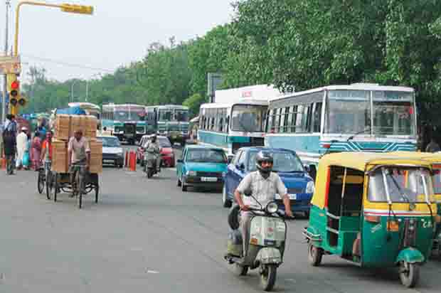
India is a country with almost one third of its 1.3 billion population in the middle class. Not all live in cities, but even if they live in villages their worldviews and aspirations are being guided by urbanism. Their idea of the city is not linked with an appreciation of the street as a space of experience and knowledge, or the street as spatial technology for management of flows of people and things. This is because, for over seven decades, we have neglected the streets of our cities. Streets have become roads for ferrying vehicles and only grudgingly accommodating people. The middle class may enjoy the experience of strolling down a shopping street as a flaneur, however their orientation to the ubiquitous urban street has been shaped by the atomised city. They have become habituated to having their favourite experiences sequestered behind boundary walls and only under very special circumstances – the celebration of festivals, the mimicry of famous international sites, the creation of extraordinary circumstances such as car-free days – do they consider stepping out. The shopping mall is the preferred public space for the middle class and it is out of bounds for the working class and the urban poor.
There has been what we might call a secession from public space. It isn’t what we theoretically refer to as the ‘death of the commons’ because the mall and the enclave could well be considered ‘the commons’ for the middle class. In fact, each class has created their own commons leading to a fragmentation of the urban experience and no semblance of an aesthetic that binds and unites.
The future of the Indian city is thus threatened by the sanitization of urban experience in segregated public spaces where homogeneity is a prerequisite for entry and inclusion.
The promise of the street is the same promise that exists in all cities in the free world, but in India the promise may be denied because of the deep stratification of society and the lack of appreciation for public space as the unifier of urban experience for all individuals that occupy the city.
As regulated commons, people places and vehicular conduits, there is a significant difference between streets in India versus the broader West. Indian streets have comparatively less stringent reinforcement and order. They are much more amoebic and appropriated. And our driving patterns are also different. While we look at the best practices and listen to rhetoric such as complete streets from the West, what cautions might we exercise in India?
There has been a sincere effort to promote complete streets through the Smart Cities Mission of the Government of India. Pune was an early adopter of the concept and executed several such streets. A number of other cities like Vishakhapatnam, Ahmedabad and Bhopal have been pursuing this idea. Most recently, one of Delhi’s busiest shopping streets in Karol Bagh has been made car-free and fully pedestrianised. Bengaluru and Chennai are executing the ‘Tender Sure’ model, which also stipulates that the entire street cross-section is developed in an integrated manner. There seems to be a new interest in making ‘places for people’ and focusing on the outcomes of urban development rather than the mere input of public funds. However, I should mention two points of caution. Firstly, a city cannot afford to create such initiatives as one-off pilots, but must establish the policy and regulatory environment that can replicate the experience in all areas. Unless this is done, the complete street remains a showcase and may only enhance the track-record of the city administration that promoted the initiative, leaving the rest of the city alienated from its benefits. This is what happened with the bus rapid transit system in Delhi, where the resistance from the elites rendered the project a failure despite the resounding satisfaction expressed by daily bus commuters.
The second caution is that all streets require efficient maintenance. Just a one-time implementation followed by daily sweeping is not enough to protect it from deterioration and eventual abandonment. The Public Works Department usually executes the job, but the maintenance is left to the municipality, thereby removing all accountability. As we have learnt from the ‘broken windows’ theory, if the administration does not attend immediately to even a single broken street light, the chances are that other lights will also be damaged. The same applies to vandalised assets of all kinds, which must be promptly repaired and restored to newness. In sum, we have to ensure that the planning and development of complete streets becomes normative.
The intellectual rhetoric of the Indian street continues to remain more appealing as a spontaneously appropriated place than as a designed room. Do we tend to underestimate the design of streets as great public rooms in India?
I must admit that I am unapologetic as an advocate for the power of design to transform urban places. Design is fundamental to the achievement of quality; in turn, quality is essential for the achievement of urbanity, that intangible sense of civic purpose and the greater common good. There is nothing particularly accidental about how cities evolve. A good indicator of this wisdom was Christopher Alexander’s attempt to articulate a new theory of urban design that tried to decipher the ‘rules’ that make cities seem as if they evolved and were not planned.
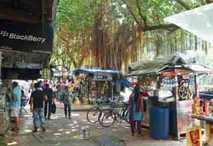
I believe that the ‘spontaneously appropriated place’ is only so because there has been a designed intervention that attracts people and encourages them to feel at home in that location. Spontaneous appropriation is a response to a conducive situation, not a phenomenon that originates from independent and isolated choices. This aspect requires greater attention because it reveals some uncomfortable truths.
To start with, we must acknowledge the extent to which streets in India have been encroached by individual property owners and neighbourhoods that abut the street or even en masse by entire residential communities or by market associations. In this respect, ‘appropriation’ becomes an illegal occupation of space for undue profit. It is also important that we realise that cities do not have the capacity to create the designs for streets. And, oddly enough, because of the shortcomings of the curricula in architecture and planning schools, Indian architects also do not learn much about this craft, with a few Master’s programmes in urban design trying to fill the gap. Most Indian city administrations do not employ planners, urban designers and architects. The city has to procure services from the private sector and that, if you consider the numbers of unique streets that need design intervention, is an unwieldy task and unlikely to be fulfilled with any predictability. We need designed cities and yet we have neither the manpower nor the administrative machinery to make that happen. Therefore, when we speak of a ‘designed room’, a street ‘cross-section’ and ‘morphology’, we must be conscious that we are speaking a jargon that simply does not make sense to the intended clientele. We must invest effort and resources into the training and capacity building of existing city staff as well as the augmentation of their capacities by recruiting the skills that are missing. The Smart Cities Mission has made efforts in this augmentation by creating a Special Purpose Vehicle (SPV), a company that has the technical manpower that is multi-disciplinary and suitably experienced, such that the city government can rely on such a team for development works. This initiative has proven to be very productive in a number of cities. We can anticipate that by 2022, once the Smart Cities Mission projects of each city are complete, the SPV and its staff could become an adjunct facility to which the city can outsource or delegate development projects. We may then have the opportunity to mainstream an appropriate approach to streets.
You did a graduate thesis on streets. What were your main findings and how do you see them in play today?
During my term at the School of Planning & Architecture in New Delhi, there was a tradition that students of the B. Arch. programme would write a research ‘dissertation’ in their eighth semester. A member of the faculty would serve as the guide, although students would be allowed to select a guide from beyond the faculty as well, depending on their topic. I had opted to write my dissertation under the guidance of architect Satish Grover, who was also an avid reader. In 1988, he somehow managed to acquire a copy of Jane Jacobs’ classic The Death and Life of Great American Cities. I borrowed the book and could not put it down till I had read it cover to cover. There was no turning back after that. My dissertation topic became ‘Streets in the City’ and I dug into the library to find relevant literature. It was not easy but I found a copy of On Streets, a compilation of writings edited by Stanford Anderson. Most students focused on architecture whereas I was fired up about streets and cities and the idea of the outdoor spaces that were just like indoor spaces but without roofs. And the occupants were the people who lived in the city. Jacobs and Anderson charged my imagination and I subsequently devoured any literature I could find that pertained to city design. William H. Whyte’s urbanism, Cullen’s quaint theory of ‘townscapes’ and the ideas of many others became my preferred reading. I recall being particularly inspired by Charles Jencks’ argument, in a special issue of Architectural Design covering entries for the Phoenix (Arizona) City Centre competition that urban design could contribute to ‘the architecture of democracy’.
My turn towards the city and away from (what I considered to be) the obsessive attention to buildings as singular objects has been a formative influence on my career.
Even today, I consider the street to be the fundamental building block of the city, not only in the morphological sense of Camillo Sitte but in the sociological and economic sense evoked by writers like Lewis Mumford and more recently by Richard Sennett. Cities are of, for and by people. Unless architects and urban designers realise this truism, they will continue to fetishise architecture as somehow autonomous from the conditions of its making.
Part of my methodology of research was to experience the city, and I remember how I was immediately drawn to Bombay – the name hadn’t changed yet – and its streets, public places and the ways that the local residents revelled in the use of public open spaces, quite unlike the anti-public habits of Delhi’s residents, who seemed more keen to frequent elite enclaves and clubs than the plaza or pavement. My own city, Delhi, had a single attractive public space, Connaught Place, along with historical market areas where the pedestrian was preeminent. The sources of my research were mostly tertiary, but the ways I related it to my lived experience made it ‘primary’. It was not a subject that I found easy to handle because of the preponderance of strictly architectural thinking in our curriculum, but I was grateful to the institution for providing opportunities such as these for broadening the minds of the students.
Streets are gaining in significance once again, thanks to the eorts of those who have championed and promoted ‘New Urbanism’. However, I realise that the street cannot regain its centrality unless architects and urban designers learn to work with social scientists and the local community. The subject of urbanism is complex and not easily understood because it requires the understanding of various concepts such as architectural determinism, behavioural psychology and social choice, that appear opaque and inaccessible to most people. This becomes difficult when there is an absence of policy and the ideas have to be communicated to political leadership at all levels. It is even possible that such ideas can seem elitist or esoteric. We must make efforts to demonstrate the value of streets in a broader social context, possibly even taking recourse to a ‘cost-benefit analysis’ to convince the decision-makers that a better quality of urban experience can be created if we pay attention to street design. This often seems an insurmountable challenge in India because of the ghettoisation of our cities. The street has become a no-man’s land, a residual and much-abused space, and to recover it from its sorry fate, the street has to be promoted at all levels – local, national and within institutions and civil society – and in all possible ways: through research, writing, teaching and public discourse.

Comments (0)