

While the Netherlands has historically been the Gateway to Europe and always had efficient mobility infrastructure, what role is Smart Mobility going to play in the future of its urban infrastructure?
In the Netherlands we strongly believe that smart mobility contributes to improved accessibility, safety and sustainability. And since the Netherlands is one of the most densely populated countries in the world, we also need innovations in the areas of traffic management and intelligent vehicles. Besides that, inventions are part of the innovative nature of the country. In addition, mobility and infrastructure are of crucial importance to the Dutch economy. That is why I continue to invest in our infrastructure. To remain a world leader in logistics in the future, it is equally important that we work on smarter forms of accessibility.
To capitalise on opportunities in the area of smart mobility and self-driving cars, a big effort is being made. The Netherlands provides a wide range of excellent opportunities to develop activities in the field of smart mobility.
To an important extent, these opportunities are facilitated by the fact that businesses, knowledge institutes and the government take a joint approach, pursue a common objective and align laws and regulations to this objective. The Dutch regulatory framework has been changed and now allows for the use of our highly extensive and sophisticated public roads system as a test environment for connected and automated driving vehicles. Not only is this allowed, it is actually possible – on motorways, in rural areas, in the Randstad metropolitan area and in cities.
The highly developed and dense traffic network in the Netherlands, the high level of traffic management, smartphone use, the 4G-penetration rate and the numerous programmes and initiatives by the government in recent years make the Netherlands an excellent place to develop, test and implement smart mobility, making use of new and existing international standards. The Netherlands has invested in reputable knowledge clusters in the automotive and technology fields and in high-quality facilities, resulting in a favourable testing, development and implementation environment.

Furthermore, the Netherlands offers the latest test facilities, up-to-date development centres, as well as highly educated professionals in the field. The Traffic Innovation Centre in Helmond serves as a prime example. Here, a partnership between the government, higher education institutions and private parties innovate and experiment together, paving the way for further innovation. Besides, we give access to open government data sources in the area of traffic information. All traffic data of the National Data Warehouse for Traffic Information (NDW) is freely available. Moreover, the Netherlands offers a mobile 4G network that provides 98 percent coverage nationwide.
Which technological advances do you see guiding the development of urban infrastructure for mobility in the future?
Both vehicles and communication possibilities will advance. This means that data and software will make it possible for people to plan their trips more easily. Moreover, we see the following developments:
1. Every single automobile manufacturer now markets cars with driver-support functions.
2. All major brands are developing highly automated or autonomous cars.
3. The first self-driving people mover – the WEpod – is making its trial runs on public roads in the Netherlands. Without a steering wheel, pedals or even a human driver!
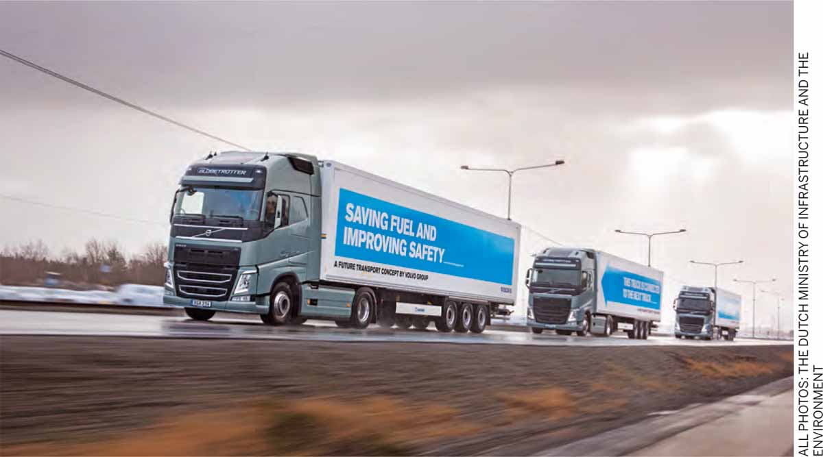
4. In April this year, we had organised the first cross-border truck-platooning event. Platooning trucks made by six different manufacturers drove from six different European countries to the Netherlands.
5. We host the European headquarters of Tesla Motors in Amsterdam. A recent update by this electric car manufacturer enables their cars to be equipped with an autopilot, without having to visit the car dealer.
The focus is shifting from engines to software.
The vast majority of Dutch adults are using smart phones and, increasingly, cars and infrastructure are getting connected to the Internet. There is an opportunity to take advantage of this connectivity to improve road safety and traffic flow in the next few years, within and between major Dutch cities.
There is a wealth of information available on the Internet about factors that affect congestion on the roads, such as the weather, road works and nearby festivals. But it’s not until you piece together the puzzle that you can really give travellers customised travel advice and driver support.
The new intelligent systems give road users individual advice based on real-time information, enabling them to anticipate what they are going to see for themselves, as well as to understand what is happening outside their field of vision.
Not only do cars communicate with one another and with the roadside to achieve this, in the very near future, they are going to communicate with traffic lights as well.
It is not just about technology. It is also about pushing boundaries, learning by doing and the need for international cooperation. There are some complex questions to which we do not have the answers yet, but this complexity should not stop us from pushing forward. Some of the country’s regions, like Eindhoven/Helmond and Amsterdam have considerable Smart Mobility experience in terms of use, product development, manufacturing, research, new business development and funding models. Interesting projects are being conducted nationally and internationally, funded by companies, knowledge institutions, national authorities and the European Union, among others.
Which measure is your ministry undertaking to underline the role of Netherlands as one of the international pioneers in the field of Smart Mobility?
The Ministry is very active (both nationally and internationally), and is conducting several programmes and projects with regional partners, research and educational institutes and the business community in the Netherlands (public-private cooperation). The informatization of traffic is growing and together with the automation of vehicles a lot of functionality can be added to save lives in traffic and to keep cities livable. In the Netherlands, we actively try to merge these developments and this approach is now being adopted to be a European approach.
Advanced technologies are being tested in combination with new forms of traffic management and collaboration in the Amsterdam Practical Trial, the Cooperative-ITS Corridor between Netherlands-Germany-Austria, the Innovation Traffic Centre and of course connected and automated driving, among other initiatives. These and other efforts are part of an integral vision and road map for better in-transit information in which government authorities and businesses are aiming for various long-term transitions to serve the public with the best possible information on actual traffic, routes etc. to decrease traffic jams.
Another example: The Brabant Region
The corporate sector, the central government and the provincial authorities combined will invest close to €100 million in cooperative, intelligent transport systems in the southern Netherlands region. The project is a large-scale, public-private partnership designed to give tangible substance to Netherlands’ leading position in the field of smart mobility. The project is a unique practical smart mobility showcase. Together with all of the parties concerned – the authorities, the market and research and educational institutes – the region wants to invest in the large-scale application of innovative concepts in the field of smart mobility and Intelligent Transport Systems (ITS), both on the trunk road network and the subsidiary road network. The ambition is to create the most intelligent motorway in Europe, starting from the Brabant corridor, interconnected with a smart regional network.
Better Use of the Roads Programme
The Netherlands makes a substantial investment in new forms of Smart Mobility. We, along with 12 other regions, are allocating more than €70 million for ITS for the period 2016-2018. This involves new technology and services that give travellers real-time driving and travel advice during their journey. Another aspect is the use of innovative forms of traffic management, leading to better traffic distribution on the roads after an event or major congestion.
Nine projects have been set up in the combined regions in the Netherlands, to deploy new services and gain practical experience with the latest technology.
For example, the Groningen-Assen, Arnhem- Nijmegen and Midden-Nederland regions and the Amsterdam Metropolitan Area are collaborating with the supermarket company Ahold on a tool to improve supermarket logistics by enabling smart heavy goods transport. In this way, 200 lorry trips per day can be structurally avoided in the regions involved.
Another project is being started to reduce the build-up of traffic due to incidents. It is being rolled out in the provinces of Brabant and Noord-Holland to begin with.
Each year, more than 20,000 lorries and 150,000 passenger cars break down on the main road network. Improved sharing of information means that both traffic management and road users can far more effectively make allowances for such incidents. With national coverage, this can result in 2.5 % reduction in congestion.
Major improvements may also be made in terms of congestion around festivals, congresses and concerts. Each year, festivalgoers account for five million rush-hour car trips in and around cities. Investing in the development of good information services and event apps allows visitors to get customised travel advice, which will optimise the area’s accessibility for festivalgoers and other road users.
Projects are also being set up on the themes of connected and cooperative intelligent transport systems, travel information services, the setting of new standards and the sharing of diverse streaming data of road managers and private parties.
What are the great achievements that we will have now that ‘autonomous’ (driver-free) vehicles will become available in the coming years? And how is your Ministry helping to initiate and support these innovations?
Smart mobility solutions, such as autonomous cars, can contribute significantly to the enhancement of sustainable mobility, free- flowing traffic and more traffic safety.
During the Dutch Presidency of the European Union in the first half of 2016, I introduced the topic on the European political agenda in the European Transport Council. The Netherlands also initiated the European Truck Platooning Challenge in 2016, during its Presidency of the European Union. This involved various brands of automated trucks driving in columns (platooning), on public roads from several European cities to the Netherlands. The Truck Platooning Challenge is a loud and clear signal to EU policy-makers: the technology is here, so let’s deliver the policy. For the first time, the impact of innovative and smart mobility was discussed at a political level in the EU. With the Declaration of Amsterdam, the transport ministers of all 28 EU member states agreed on the steps necessary for the development of self-driving technology in the EU. The agreement pledges to draw up rules and regulations that will allow autonomous vehicles to be used on the roads. The Netherlands continues to innovate and push on the subject and has recently published new plans to experiment with vehicles without a human driver.

Comments (0)