When the late Prime Minister of Singapore Mr Lee Kuan Yew planted a Mempat tree on the first tree planting day on 16th June, 1963, he effectively planted the seeds of a vision for creating a City in a Garden in Singapore.
In the past five decades, the city-nation of Singapore has been able to achieve significant results towards achieving this aim. As a visitor one comes to the conclusion that Singapore can today truly be called a lush, verdant city – a city cloaked in green. And new projects under development and construction suggest that the use of landscape in the city is being encouraged and intensified.
Singapore has been able to achieve these results in spite of its high density as a city-state. With a density of approximately 8,000 persons/sq.km., Singapore’s density is comparable to that of other major cities around the world. Yet despite this high density of the urban population, the use of landscape and green in the city is being achieved by consistent policy and creative design.
Consistent Policy
In the last five decades a clear policy on the restrictive use of private cars has been complemented by the encouragement of walkability and creation of a high quality of public transport network. This has created the background for achieving compact urbanization, in which landscape and green play an important role. Additionally, the policy of restrictive use of the private car has had great environmental benefits.
Such policies of great wisdom have been backed by the creation of specific organizations which have the power to promote and help achieve these goals.
In this matter, two organizations deserve special mention:
The Urban Redevelopment Authority (URA) is Singapore’s land use planning and conservation agency. URA’s mission is “to make Singapore a great city to live, work and play in”. URA is responsible for facilitating Singapore’s physical development in partnership with the community and is also the main land sales agent for the government. Its office contains an exhibition space with models, maps and other audio-visual material of great quality for all citizens to come and appreciate and thus understand the intent of the planners, landscape architects and architects.
The National Parks Board (NParks) is responsible for providing and enhancing the greenery of Singapore. NParks is responsible for creating green infrastructure in Singapore and engaging the community to achieve the goal of enhancing the quality of the urban environment.
Not only does NParks manage four nature reserves and over 300 parks, but is also responsible for the extensive green streetscape in Singapore. It aims to also achieve bio-diversity in urban landscape. NParks has used the financial initiative programme for owners to retrofit their existing buildings with greenery, with subsidies for up to 50% of the costs for greenery. Finally, the Centre for Urban Greenery and Ecology (CUGE) has been instituted not only for professionals but also to inform the general population.
Together, these organizations have created a fertile ground for the architects and landscape architects of Singapore to work on integrating landscape in architecture. This is being done in the form of roof-top gardens, green roofs, sky terraces, landscaped balconies, green walls and multi-layered landscaped spaces. The use of such increased landscape in the urban context leads not only to a visually pleasing urban atmosphere but helps achieve the following five aims:
A. Creating spaces for recreation and other amenities for the use of communities.
B. Improving building performance through reducing solar heat gain thus helping to reduce the building’s and the city’s total energy usage.
C. Reducing the impact of buildings on its environment not only visually but also by reducing the pace of the water run-off and reducing the urban heat island effect.
D. Increasing the floral and faunal diversity in the built environment.
E. Improving the visual quality of the urban context.
But above all it will achieve, as Ian Mcharg, the eminent Scottish landscape architect and writer stated in his book The Place of Nature in the City of Man (1964), “Yet there is a need and place for nature in the city of man. An understanding of natural processes should be reflected in the attribution of value to the constituents of these natural processes. Such an understanding, reflected in city building, will provide a major structure for urban and metropolitan form, an environment capable of supporting physiological man and the basis for an art of city building which will enhance life and reflect meaning, order and purpose.”
In the three examples of major architectural projects illustrated in this article and the incorporation of landscape in them, the evolution of multi-layered landscaping in Singapore is evident.
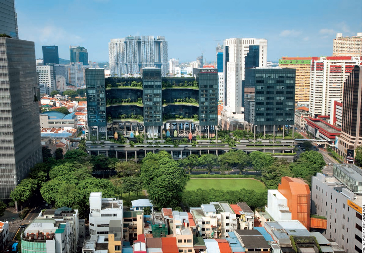
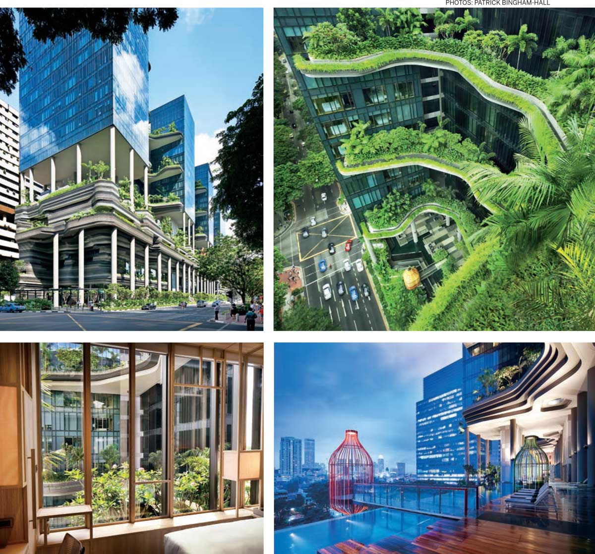
Park Royal on Pickering (Office and Hotel)
At this site located in the central business district of Singapore, WOHA Architects demonstrate that even in a high-density mixed-use (office cum hotel) development it is in fact possible to increase the greenery on the site. On a site facing the Hong Lim Park, the design “brings the park across the road and folds it up vertically into the building”. A total of 15,000 m2 of sky gardens, reflecting pools, waterfalls, planter terraces and green walls have been designed - roughly double the size of the site on which the new development was built. The four-storey high sky gardens are zero-energy, completely powered by pv cells on the roof. The layered terrace gardens are not only aesthetically pleasant but also functional in mitigating thermal gain on the west-facing wall and thus improving the quality of the indoor areas.

Pinnacle @Duxton (Social Housing)
The development of this site at the edge of the traditional China Town was part of the government’s drive to facilitate the housing of nearly 100,000 persons close to the city. On a tight site of nearly 2.5 ha. architects ARC Studio won the competition to accommodate 1848 housing units. The seven tall slabs towering 50 storeys above ground are linked on the 25th and again on the 50th storey with a landscaped element that creates a communal green space ‘reclaimed from the air’. These two elevated ‘Sky Gardens’ weave the seven tower blocks into large linear landscaped spaces in the air and between the tower blocks form nodal elements like a Sky Gym, a hillock, a lounging space or children’s playground. They function as an extension of the living environment of the residents forming almost one hectare of new land! In addition to these two landscaped levels in the sky, on the ground too, a sculptural multi-level design of the landscape peels and flows over the car park providing a gently rolling mound at the bottom of the complex that helps establish a good relationship with the small-scale of the neighboring developments.
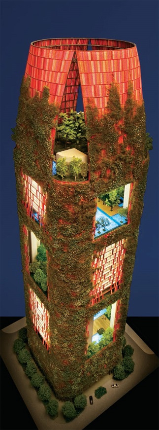
Oasia Downtown To wer (Commercial high-rise including hotel and offices)
This project, designed again by WOHA Architects, is presently under construction. It is important because it tries to create an alternative imagery for commercial high-rise towers in an urban context, which according to the architects “showcases a perforated, permeable, furry, verdant tower of green in the heart of Singapore’s Central Business District”. In response to the different functions in the tower, the architects have created a sort of ‘club-sandwich’ with a series four sky gardens being interspersed over the nearly 30-storeyed tower creating a total amount of landscaped space far larger than the tight site of the tower.
Landscaping has also been used extensively as an architectural surface treatment and the built form of the tower will be softened by a living green facade of creepers and flowering plants, giving the tower a softer silhouette.
Since the project is still under construction, the final judgement on the appearance will have to wait, yet the typological solution to have a series of landscaped sky-gardens is promising.
 |  |
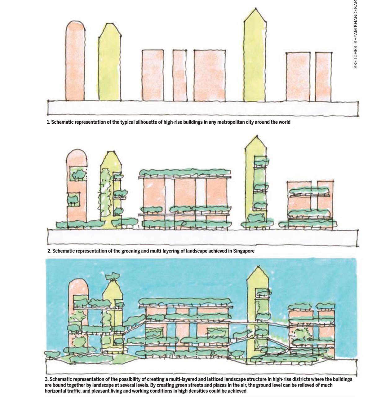
In all of the above projects, what we notice is the intent to create landscaped spaces at different layers above ground. The landscape and greenery are not restricted to the original ground level, but in a compact urban setting is being ‘layered’ at several levels and ‘claimed from the sky’. While these newly created raised landscapes in each of these buildings are only meant for communal use for those either living or working in these buildings, the regular use of these landscapes in high-rise buildings brings closer the almost utopian prospect of creating a high-rise city where a latticed landscape structure connects several buildings together. With the development of new technology in lift-techniques such a landscape may not be that far away.

Comments (0)