Cities in developing countries are experiencing an astonishing pace of urbanisation and rapid growth, which has led to an unprecedented increase of transportation infrastructure investments. On a global scale, almost 1,500 urban rail infrastructure projects are being constructed, amounting to a total of 140,000 km of new rail lines, as of 2017. The growth of urban transit represents the potential for a better standard of living for countless people, as a connector to economic opportunities and jobs. However, if transportation infrastructure is delivered without thoughtful consideration of the communities it serves, or the critical issue of focusing urban density, cities will be unable to fully leverage these significant investments and miss a once-in-a-generation opportunity to shape vibrant and sustainable cities through increased transit usage and access.
Sustainable transit development is more than just infrastructure
Transportation agencies are typically incentivised to deliver transit projects at a fast pace. Most capital funding sources for transit usually have strings attached and fast delivery ensures mitigating against cost escalations. In highly urbanised cities, land acquisition for transit alignments is another key challenge and transportation developers typically want to keep land acquisition requirements to a minimum.As a result, transit projects are often thought of as pure infrastructure, meaning they are planned in isolation from the greater social and physical environment. While simplistic, this strategy follows the path of least resistance. But, if transit lines and stations are planned with a long-term goal of creating dense, walkable, well-connected nodes, it can have a significant impact on the use and value of the land surrounding it. Increased job opportunities, knowledge spillovers and efficient land use leading to higher transit usage are among the many benefits that are associated with high density, transit-oriented communities. This value is usually manifested in the form of private investment, particularly real estate development around station areas and along transit corridors.
While transit and associated development is an economic developer’s dream, too often it has the unintended consequence of gentrifying neighbourhoods and displacing residents who could benefit from transit the most. What some academics have dubbed ‘transit-oriented gentrification’ has been observed in cities around the world, with sufficient evidence that transit proximity, in conjunction with an insufficient housing stock, is often linked to increased housing costs and loss of low-income households.
Value capture and transit-oriented development
Under the right conditions, the public sector can capture increased economic value catalysed by transit infrastructure and create funding streams that utilise a multitude of ‘value capture’ mechanisms to not only fund transit infrastructure and public realm improvements, but also support equity initiatives like affordable housing and workforce development. Doing this requires big-picture thinking and proactive collaboration among city planners, economic development advocates, the private sector, community stakeholders and infrastructure agencies at the earliest stage of planning.
Urban transit is particularly well-suited for value capture because it presents the opportunity for development and revitalisation, as shown in cases like the rail property model in Hong Kong, which unlocked development potential for over 600,000 public housing units. It is well known that the success of Hong Kong’s Mass Transit Railway (MTR) system is hinged on the proactive strategy of focusing all of the city’s urban growth within close proximity to its transit infrastructure. The MTR benefits directly from the private investment that occurs on publicly-owned properties adjacent to transit stations or from the sale and use of ‘air rights’ above stations, as well as a number of ancillary revenues like retail and advertising within stations. They in turn can use these resources to invest in transit and other community benefits, completing a virtuous cycle of investments and benefits.
Value capture can be a critical element for cities to be able to fully leverage their public investment in transit infrastructure, in a manner that is economically sustainable and creates sustainable transit-oriented communities.
But the ability to create value from transit investments in the first place depends largely on better integrating transit infrastructure with its physical surroundings.
By integrating planning and value capture strategies early in the process before alignments are set, transit agencies can identify areas where transit is most urgently needed, urban designers and planners can design an interface that optimises access and adds most value, economic development professionals can design appropriate value capture tools and, most importantly, transit developers can engage with community stakeholders to determine which services and community benefits are most desired.
The end goal is to have active station areas and higher ridership
Metro de Medellín: A holistic approach to transit-oriented urbanism
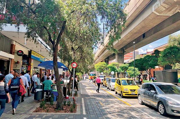
In Medellín, Colombia’s second largest city with almost 4 million people, the public transportation agency in the Valle de Aburrá Metropolitan Area, co-owned by the City of Medellín and the State of Antioquia, has played a significant role in driving an urban renaissance through a series of public investments in elevated rail, light rail, gondolas and bus rapid transit. A foundational principle of Metro de Medellín (‘Metro’) was building the Cultura Metro (Metro Culture), or the cultural identity and shared purpose for public good, to help develop marginalised sectors of the Metropolitan Area through transit investment. Metro has since changed the concept of public space in a city built for businesses and factories.
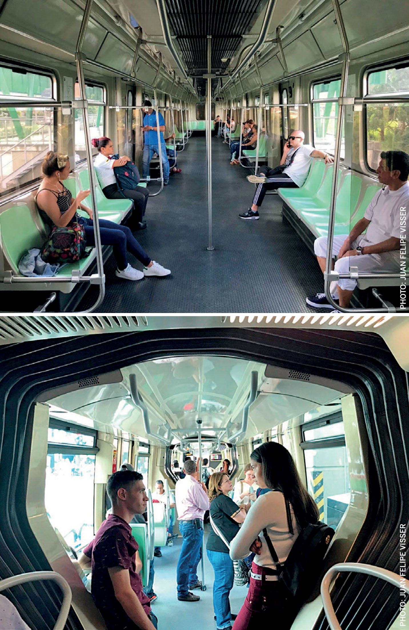
Today, areas managed by Metro, including trains, trams, cable cars as well as stations, are perhaps some of the best cared for public assets in the region. While part of this is related to the operational efficiency of Metro as an organisation, for the most part it is a manifestation of Cultura Metro, which reflects a great level of community pride related to the public transportation system. Metro’s goal, as an urban infrastructure provider and city-builder, is to ensure that Cultura Metro permeates the entire urban realm, not just within the transit system, but starting with the station areas and surrounding neighbourhoods. To do this, Metro has taken steps to proactively think about integrating transit with its surrounding communities using a range of strategies, but three of them stand out in particular:
1. Bring everyone to the table to start thinking about land use from the very beginning. And develop close collaboration and coordination between transit agencies, city planning and land-use authorities. If a broad range of stakeholders is not communicating prior to implementation of complex infrastructure projects, you cannot leverage your investments. A wide variety of people must be involved in implementation to ensure that transit infrastructure will be integrated rather than disruptive.
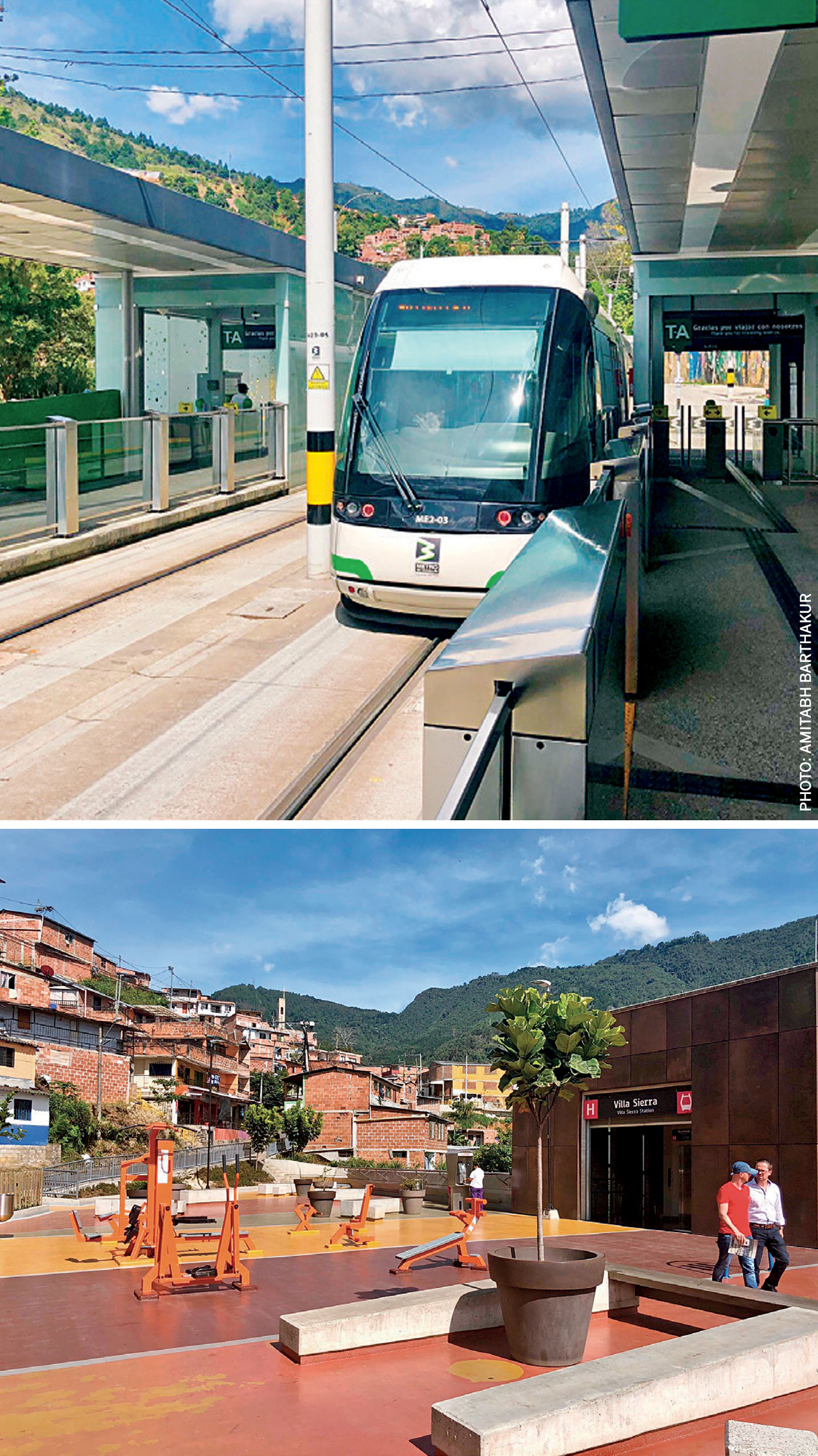
The collaboration of several public institutions was a key factor in Metro’s success in completing a variety of complex projects that complement its core transportation initiatives, which included cable cars that connect informal settlements to the transit system. Over time, Metro has also built internal capacity for interdisciplinary collaboration, with an urban development team of more than 30 planners, architects, real estate and financial analysts that work closely with their transportation planning team and the City of Medellín ’s department of city planning, to deliver projects in an integrated manner. The agency is expanding its system and, for each line like the new Ayacucho Tram and H-Line Cable Car, they have started to define ‘influence’ and ‘intervention’ areas around stations and the alignment. Intervention areas, immediately adjacent to transit stations, are slated for physical interventions by Metro, particularly in terms of public realm, signage and access improvements. Influence areas, within the larger surrounding neighbourhood, are planning areas that will directly benefit from new transit investments, generate ridership and present value-capture opportunities.
Cultura Metro permeates the entire urban realm, not just within the transit system, but starting with the station areas
2. To give transit agencies greater control on land-use along alignments. The City of Medellín is today in the process of granting Metro formal status as ‘Operador Urbano’ (Urban Development Corporation), which will give the agency greater jurisdiction over land use issues, proximate to transit. Beyond defining design guidelines, open space projects and pushing transit supportive zoning, Metro will have the jurisdiction to apply eminent domain, collect revenues from certain value capture mechanisms in special financing districts and manage the open space and public realm within intervention and influence areas. While empowering transportation agencies to implement station area development may not work everywhere, Metro’s demonstrated commitment towards a better urban environment combined with their intellectual and technical capacity to accomplish their goal of integrated transit use, can be very effective. This novel approach ensures that planning for station areas happens early on and mitigates any conflicts between transit infrastructure delivery, operation and the surrounding environment, in turn supporting greater ridership and enhanced economic benefits.
3. Strategically acquire land for alignments in a manner that supports better integration of transit stations with the surrounding station area. Trying to integrate surrounding land uses with transit infrastructure, once the infrastructure is already built, can be a challenging if not an impossible task. Metro’s approach to transit planning includes proactive strategies to acquire land, particularly around stations, that have the scale and capacity to be developed later. As transit stations are the primary interface between the transit system and the rest of the Metropolitan Area, this approach ensures station areas can support transit-oriented development, as well as safe and easy access to stations. The end goal is to have active station areas and higher ridership. Planning around Medellín ’s Metro system also involved developing land in areas with little or non-existent public investment, with a focus on improving public infrastructure and amenities such as parks, libraries and streets.
Seeing the benefits
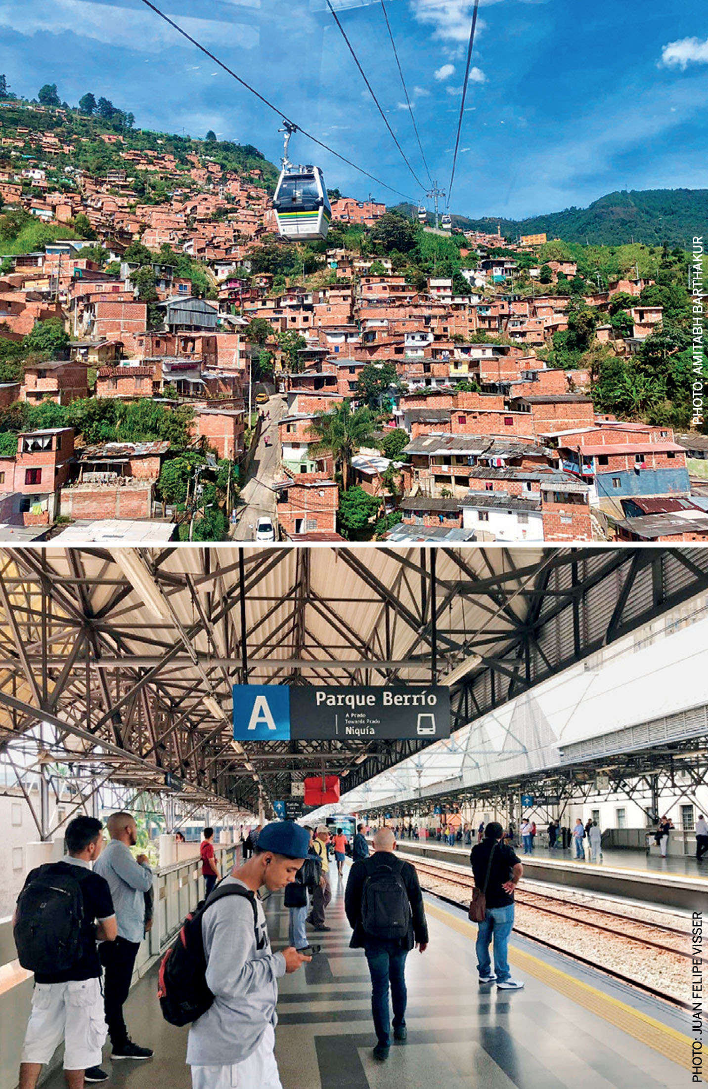
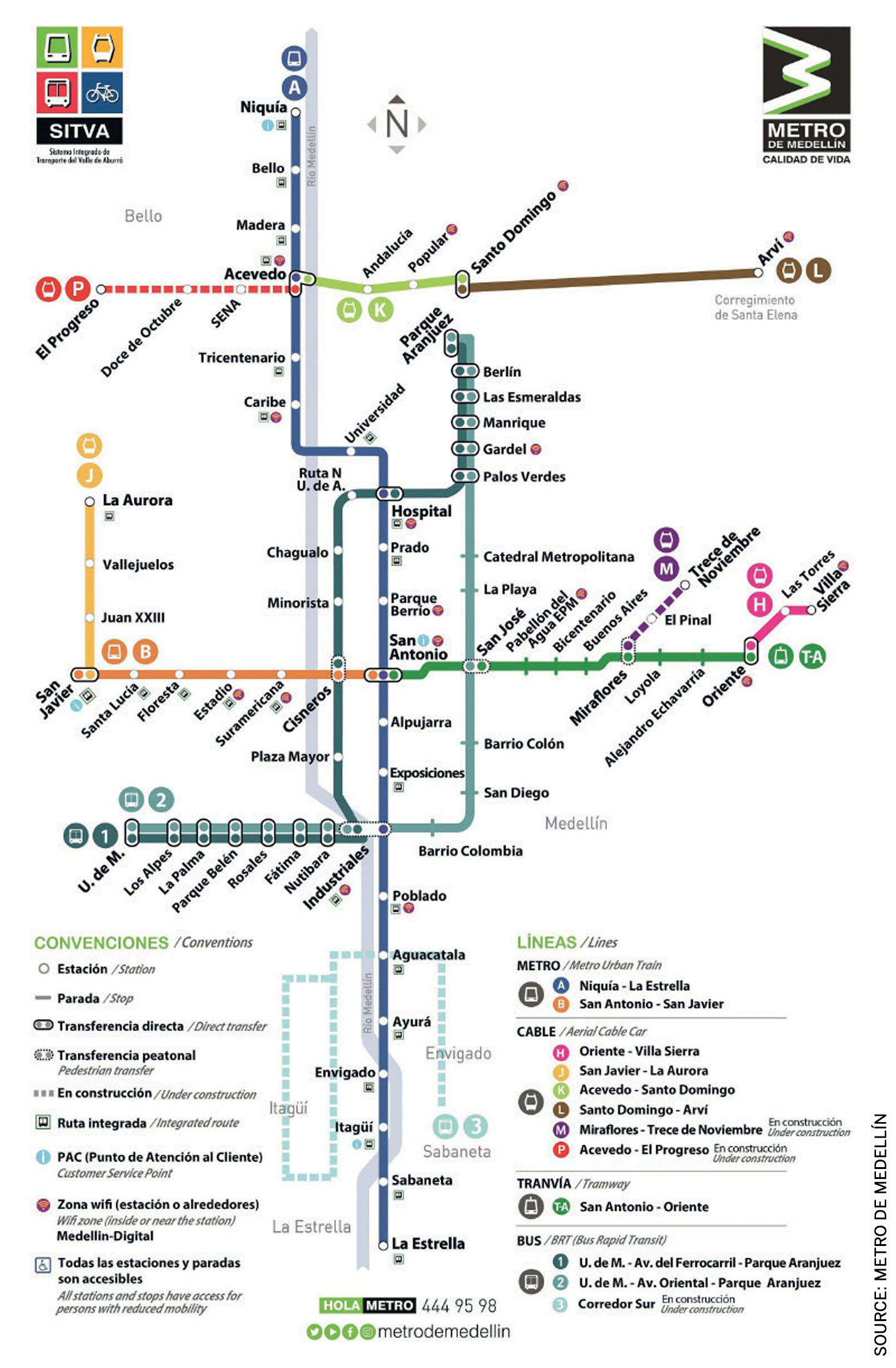
Medellín’s integrative planning process has helped the city harness the value of transit not just in dollar terms, but also in improved quality of life and decreased rates of crime, transforming the city for many generations to come. Medellín is a narrow valley and Metro operates a range of interconnected modes to maximise transit access to all communities. This includes heavy rail that forms the backbone, connected by trams to the edge of the valley, which are further connected to cable cars that provide access to neighbourhoods on the hillsides.
Marginalised communities located on the hillsides surrounding Medellín have benefited by having their travel time to the city centre reduced from an hour to less than ten minutes – improving their access to employment opportunities and other resources in the formal city. The MetroCable aspect of Medellín ’s transit system exemplifies how transit can be used to benefit those who have low access to transportation in the first place.
Public safety is another aspect of quality of life that has been improved for countless people in Medellín – the murder rate in the city has fallen by more than 80% since 1991, the decade before many of the integrative planning projects were introduced. The new stations themselves have also transformed neighbourhoods into resource-laden cultural and social hubs, with many libraries, schools and sports facilities being built around transit stations. Investment in holistic transportation planning that accounts for improved connectivity and quality of life has worked to transform the social fabric of Medellín into one of Colombia’s most liveable cities.
How can this work elsewhere?
Lack of cooperation between multiple stakeholders early on in the transit planning process is a major roadblock in creating plans that encourage dense and inclusive growth, and support long term economic sustainability of cities.
Urban planning and design professionals have a responsibility to advocate that their respective cities build capacity around inclusive and integrative planning by engaging public, private and civic actors early on in the planning process. We need to recognise that transit infrastructure development, economic development, community development and real estate development are not discrete activities that contribute to city building. They are inter-related processes that have symbiotic relationships with one another. While there may be a set of private and public actors who appear to have discrete roles in these activities, the lines between them need to dissolve if we are to create liveable cities.
Amitabh Barthakur is a leading land-use expert and development economist. He’s worked with cities and transit agencies around the world to think through how real estate development and land use can provide value capture opportunities for transit systems and cities.

Comments (0)