A strip of blue tape on the ground was called litter in 2019. Now? It’s a critical signifier of order and safe distancing across our physical environments. In an effort to stabilise businesses and social spaces in the Covid-19 era, signage and visual communication has erupted into our spaces demarcating distances, mandating masks and advocating for greater self-awareness. There is no style guide; messaging, aesthetics, and instructions are communicated with minimal consistency and have added up to a dizzying cacopohany of visuals. As I reflect on our cities sprinting to shift behaviours to stop the spread of a virus, I am craving order to the communication. Wouldn’t a more coherent, universal approach be more impactful and better reflect the importance of the outcomes?
From U.S. anti-malaria posters in World World II to the ‘Kick Back Ebola’ posters in Sierra Leone in 2014, public health and graphic design have had an enduring, well-established relationship.
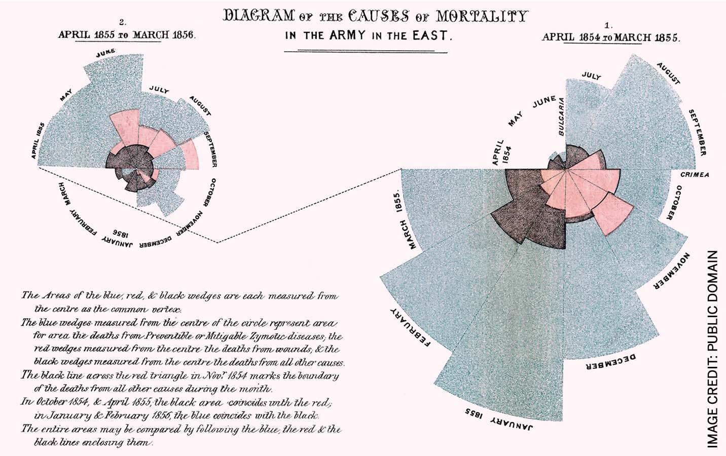
One pivotal expression of this relationship is through the sharing of critical, statistical truths with Florence Nightingale converting data sets of Crimean War casualties into her ‘polar area chart’. An English statistician, nurse and social reformer, her pioneering visualisations of statistics in the mid-1800s convinced Queen Victoria, the Parliament and civil servants – those unable to interpret tables of data – that hygiene and preventable diseases were by far the most severe causes of soldiers’ deaths. Visualising complex health information, in Nightingale’s words, was “to affect through the eyes what we fail to convey to the public through their word-proof ears.”
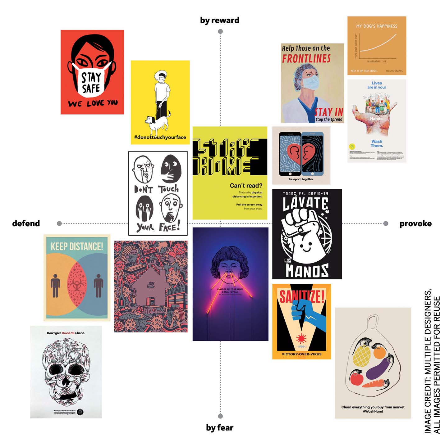 |
To affect through the eyes is, at its core, a great purpose statement for visual communication, and inspires profound outcomes when applied to public health. In a first of its kind move, the United Nations issued a global, open brief in May 2020, seeking help from visual communicators in a campaign to stop the spread of Covid-19. The resulting submissions, though rooted in common messaging and focus, are divergent in the way they seek to address behavioural changes. Of the thousands of submissions, consider this sampling and how they reflect the decisions communicators make regarding tone, desired action and motivation.
As much as these submissions are alike in their advocating for healthy choices, they are wildly contrasting in manner and reaffirm a deeply human story about behaviour: we are diverse in our stimuli and in our communication. How we nudge behaviour takes many forms. We might leverage psychology, behavioural research, A/B testing or personas to find statistically significant response rates and ideal messaging. We can consider whether people wear a mask if we share transmission statistics, appeal to their compassion for others or shame them for not being considerate.
I now see the diversity of responses and dissonance of execution as evidence of a tremendous, unparalleled effort to rapidly deploy messages of significant change across a myriad of cultures and contexts
Our pandemic reality is that without the luxury of time to create a brief, research markets or establish guidelines, messaging and signage were launched unfettered. The resulting clutter is in need of help, but speed-to-market and local adoption, particularly in response to a global crisis, is perhaps the chief metric that Covid-19 visual communications should be judged by.
I now see the diversity of responses and dissonance of execution as evidence of a tremendous, unparalleled effort to rapidly deploy messages of significant change across a myriad of cultures and contexts. That we have all collectively built a sense of new protocol is a remarkable part of our shared human story in 2020, and perhaps an effort to tightly manage the execution of these visual communications would have not only delayed impact, but diminished the humanity on display.
Should we be better organised next time? The UN open brief shows that there is a global and crowdsourced design team willing to help influence public health. How to harness this resource, for impact and for speed, is a challenge that blue tape alone cannot solve.

Comments (0)