Eindhoven scores consistently very high in international comparisons as one the most innovative cities where technology drives the city to success. How has technology nestled itself into the genes of your city?
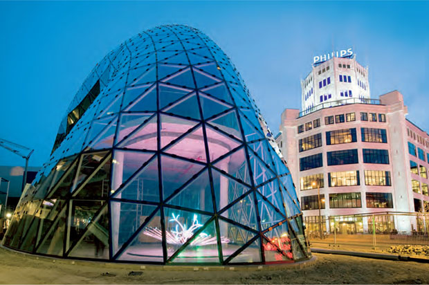
Well, this started off long ago in 1891, when the Philips brothers – Anton and Gerard – came to town to start a light bulb factory in an existing factory building. They were well ahead of their time; they realized that surviving in a very competitive world meant you have to come up with new products, renew your existing products and use new technology to innovate. So, they started the NatLab, where they did elementary physical research. This Natlab became the cradle of many inventions: radio, television, the phonograph; all existing techniques, which were modified to be used for a larger audience. There were also original findings by Philips: think about the cassette recorder, the video recorder, the compact disc and also high-profile medical equipment such as the MRI-scan.
So, this small light bulb factory – the building still exists today in the centre of our city – grew to an enormous plant that was self-sufficient. The power was generated there, the machines to make the products were made there, the glass for the light bulbs as well as the glass used in radios and TVs was made there; it was a manufacturing city on its own. And everyone in Eindhoven worked for Philips. So, if you ask me how technology became part of the genes of the citizens of Eindhoven, this is where it started.
Later on, Philips founded our technical university. This led to a new upward swing of the high-tech environment, getting lots of young people from outside to study in Eindhoven, to invent in Eindhoven and become an integral part of Eindhoven.
photo: Rens van Mierlo
You describe Eindhoven as a one- company city. But when we look around today, there are hundreds of technological companies, among them some large ones. Apart from Philips, there’s also ASML and NXP, who are world players. How did this development take place?
Well, you could say it takes a misfortune to find fortune. About 20 years ago something disastrous happened that triggered the rise of our city as one of the world’s leading technological hotspots. An economic crisis resulted in broadening the technological scope of this region. In the ’90s of the previous century, Philips was on the verge of a breakdown. Another industrial company in town, DAF, making cars and trucks, went bankrupt. More than 30,000 men and women lost their jobs. It was a social disaster.
The mayor at that time, Rein Welschen, did a very smart thing: he raised money from all the 21 municipalities in the region, about 10 guilders (at that time) per inhabitant, he managed to get it doubled in Brussels and so created a fund. It was a relatively small fund but with large consequences.
A board comprising representatives of the government, companies and knowledge institutes was formed and everyone with good projects to help overcome the economic misery could approach them. The board decided which plans would be funded. That was the start of Brainport, the triple helix structure that still exists.
Here I’d like to point out that it was a unique move: public money was given to companies to fulfill their plans. I know of no example in the world where public money was spent with such confidence.
We overcame the crisis; Philips still exists, DAF restarted and focused on making only trucks and is doing very well. The restructuring of Philips over the years resulted in the growth of other OEM-companies, among them the ones you mentioned: ASML and NXP.
So, this economic crisis was a wakeup call.
More like the last call before the pub closes! One of the insights that Philips had due to the economic crisis of the ’90s was that the path from research to inventing products to market access was too long for one company, even for a major player like them. So, what they did was open up the world-famous NatLab and turn it into a High-Tech Campus where other technological companies could join their research, share facilities and let talent work together. This was the thought of Open Innovation and this cooperation really gave the innovative atmosphere in our region a boost. Now we have the smartest square kilometer in the world.
I remember going to Samsung in North Korea in my first year as a mayor here. I wanted them to join the activities on HTC. I was received with courtesy. They must have thought this is a strange mayor, asking us to cooperate with our greatest competitors. So, I flew back to the Netherlands, empty-handed.
But six months later there was a call from Seoul. They had thought it over, and yes, they were willing to talk about a joint venture with HTC.
Now, the largest Samsung R&D plant outside South Korea is in Eindhoven. So even the most skeptical can be convinced that there are more advantages than risks in working together.
As Mayor of Eindhoven, have you taken special steps to involve different sections of the city, namely the private sector, the knowledge institutes and the citizens to work with the civic body which you head in an effort to increase the use of technology in making your city more liveable?
This is a good question because you link technology to people who have to work with it. Although this relation seems to be evident, technology has a tendency to dominate, so the focus shifts to the machine, not the man. For a government or a city council, technology can give you power when used top down. It can put you in control. But technology is all about improvement of life, so it’s a stimulus for horizontal moves. There is lots of talk all over the world about smart cities. But I don’t think they exist: it’s the people who make things smart, the people shouldn’t be end users but co-developers of technological systems. Humanizing technology is what we need. That’s why I think the term ‘smart city’ should be replaced by ‘smart societies’.
What we do in Eindhoven is create field labs or roadmaps with companies, our citizens and universities to upgrade our systems together. For example, we have a roadmap to be energy neutral by 2045.
And then we have Light-S, an innovative programme where we investigate how lighting can be applied to create new urban experiences, applying innovative techniques in a dynamic and spatial context. The dream of Light-S is that lighting on Strijp-S – the formal Philips plant and now a city-restructuring area – will not only be functional but also aesthetic and interactive. It doesn’t view spectators as passive citizens. Light-S also views the public space at Strijp-S as an established research centre.
The advantage is obvious: the projects are made with our own citizens, so they will be most user-friendly and an answer to the problems experienced by citizens. At the same time, the advantage for the companies is, when they succeed, they will have a splendid showcase with which to beat the markets. This approach benefits all.
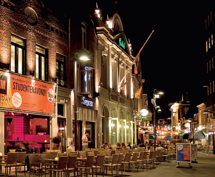
PHOTO: ZOOM.NL/van Ickal73
How does the use of technology make the daily life of an average citizen of Eindhoven easier and better?
I’ll give you two different examples: the first is a real field lab in Stratumseind, which is the nightlife hub of Eindhoven. It is a cooperation between the Philips Company, the TU/e and the bar and restaurant owners in Stratumseind. The field lab experiments with what light can do to the behavior of people, especially in aggressive settings.
Different interactive light scenarios have been developed; color, intensity and dynamics of light affect people and their social behavior. It can focus attention, create an atmosphere and so work as a social cue. I’m proud to say the project, called De-escalate, won the national safety award, the Berghuis Safety Award 2014 (www.de-escalate.nl)
Then we have ‘Smarter Life’, a health-cooperation, which is quite successful. As you know, society is changing and people are becoming increasingly older but they also want to be self-reliant for as long as possible. This demand for high-quality, efficient and affordable healthcare grows and technology makes this possible.
That’s exactly what the cooperative ‘Slimmer Leven 2020’ (Smarter Life 2020) does: to encourage and develop technological innovations that help patients become more self-caring during various (chronic) illnesses and to stimulate behavioral change among both citizens and healthcare professionals. Take for example internet platforms like the ShareCare Zorgsite, Zorg voor Elkaar and WeHelpen.nl.
Also, the ‘Persoonlijk Health Record’ is a technological solution which gives people insight into the healthcare they receive and so gives them more control over their own health. And with mobile apps such as ‘thumbs up’ people can make it clear if they need help or assistance in any way or want a chat. With CQ Live people can organize the health partner, to make sure everything is tailormade and within budget-calls from their health insurance. (www.slimmerleven2020.org/en/about-slimmer-leven-2020)
These are just a few examples. Our field labs are making more strides that are beneficial for both our inhabitants and the companies, which create showcases to be issued in other cities. I believe Eindhoven can be a cradle of these developments, which are occurring all over the world.

Comments (0)